- Geosense
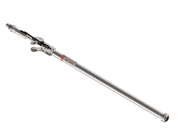
In Place Inclinometer
The In-Place Inclinometer (IPI) is a high-precision instrument designed to monitor lateral ground or structural movement continuously and in real time. Because geotechnical conditions can shift quickly, engineers need a system that captures subtle changes before they escalate into safety risks. That’s exactly where the IPI delivers exceptional value.
IPIs are installed inside inclinometer casings, forming a chain of sensors positioned at multiple depths. As the ground or structure moves, each sensor detects changes in inclination. The system then converts these angle changes into displacement, giving engineers immediate insight into movement patterns. As a result, project teams can respond before issues escalate.
Furthermore, IPIs are ideal for long-term monitoring. Unlike manual inclinometer readings, which require frequent site visits, an IPI system provides automated data collection. With the help of integrated loggers and telemetry, the information is transmitted directly to a cloud platform for visualization and analysis. This significantly reduces manpower requirements while also increasing accuracy and frequency of measurement.
The IPI is widely used in applications such as slope stability assessment, retaining wall monitoring, tunneling projects, deep excavations, embankments, and landslide-prone areas. Because these environments demand high sensitivity and reliability, the IPI’s rugged design ensures dependable performance even under harsh conditions.
In addition, the system supports real-time alarms. When deformation exceeds preset thresholds, alerts can be sent instantly via SMS, email, or platform notifications. This early-warning capability enhances site safety and helps decision-makers act quickly.
Overall, the In-Place Inclinometer is an essential solution for any project requiring continuous deformation monitoring. With automated measurement, real-time insights, and a stable long-term performance profile, it gives engineers the clarity they need to manage geotechnical risk effectively.

Advantages
Continuous monitoring eliminates the need for manual inclinometer surveys.
Minimized site visits, reducing operational cost and safety exposure.
Fast detection of movement trends for early-warning systems.
High reliability even in landslide-prone or extreme weather environments.
Better decision-making thanks to real-time analytics and clear data trends.
Flexible deployment for deep excavations, tunnels, slopes, and retaining structures.
Scalable design allows short or long chains depending on project needs.
Key Features
- Real-time deformation measurement across multiple depths.
- High-accuracy MEMS sensors for stable and repeatable readings.
- Modular sensor chains customizable to any casing length.
- Rugged construction suitable for harsh geotechnical environments.
- Automated data logging with optional wireless or wired telemetry.
- Easy integration with cloud platforms for visualization and analysis.
- Low power consumption for long-term monitoring.
- Instant alarm notifications when movement exceeds thresholds.